
The Grapevine: is I-5 open?
The Grapevine is closed in both directions right now near Lebec for roadway excavation, according to Caltrans. Do not start the drive; read the closures list below and check QuickMap before you go. It is 48 degrees at Tejon Pass.
Last updated at: 1:42 AM Pacific · Caltrans
Live cameras
Open the full strip LIVE
 LIVE
 LIVE
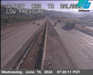 LIVE
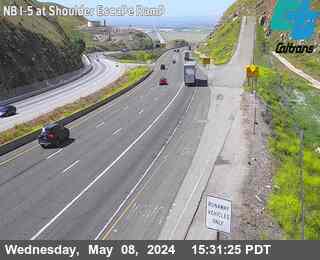 LIVE
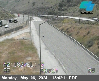 LIVE
Official Caltrans CCTV stills, refreshed by the state. Cameras shown in driving order.
The Grapevine is Interstate 5 over Tejon Pass: the 40 miles of mountain freeway between Castaic and the Route 99 split south of Bakersfield, and the main door between Los Angeles and the Central Valley. It climbs to 4,144 feet on grades up to 6 percent, carries an enormous freight stream, and closes for snow, ice, wind, and fog often enough that 'is the Grapevine open' is one of the most asked road questions in California.
This page puts the whole grade on one screen: the live Caltrans verdict first, then the cameras in driving order from Castaic to Bakersfield, the chain control posting at the corridor's checkpoints, the closures Caltrans has active right now, and the message signs over the road.
Pass conditions
40 miles, about 45 minutes in free flow, summit Tejon Pass, 4,144 ft
Active closures on I-5
- FULL CLOSURENorth I-5 near LebecRoadway Excavation, All of 4 lanes closed, delay: Not Reported
- FULL CLOSURENorth I-5 near LebecRoadway Excavation, All of 4 lanes closed, delay: Not Reported
- FULL CLOSURENorth I-5 near LebecRoadway Excavation, All of 4 lanes closed, delay: Not Reported
- FULL CLOSURENorth I-5 near LebecRoadway Excavation, All of 4 lanes closed, delay: Not Reported
- FULL CLOSURENorth I-5 near LebecRoadway Excavation, All of 4 lanes closed, delay: Not Reported
- FULL CLOSURENorth I-5 near LebecMiscellaneous Work, All of 1 lanes closed, delay: Not Reported
- FULL CLOSURESouth I-5 near LebecMiscellaneous Work, All of 1 lanes closed, delay: Not Reported
- FULL CLOSURENorth I-5 near CastaicPavement Rehabilitation, All of 4 lanes closed, delay: Not Reported
- FULL CLOSURENorth I-5 near CastaicPavement Rehabilitation, All of 4 lanes closed, delay: Not Reported
- FULL CLOSURESouth I-5 near CastaicPavement Rehabilitation, All of 4 lanes closed, delay: Not Reported
- FULL CLOSURESouth I-5 near CastaicPavement Rehabilitation, All of 4 lanes closed, delay: Not Reported
- FULL CLOSURESouth I-5 near CastaicPavement Rehabilitation, All of 4 lanes closed, delay: Not Reported
- FULL CLOSURENorth I-5 near CastaicPavement Rehabilitation, All of 1 lanes closed, delay: Not Reported
- FULL CLOSURENorth I-5 near CastaicPavement Rehabilitation, All of 1 lanes closed, delay: Not Reported
- FULL CLOSURESouth I-5 near CastaicPavement Rehabilitation, All of 1 lanes closed, delay: Not Reported
- FULL CLOSURESouth I-5 near CastaicPavement Rehabilitation, All of 1 lanes closed, delay: Not Reported
- FULL CLOSURESouth I-5 near CastaicPavement Rehabilitation, All of 1 lanes closed, delay: Not Reported
- FULL CLOSURESouth I-5 near LebecRest Area Maintenance, All of 1 lanes closed, delay: Not Reported
- FULL CLOSURENorth I-5 near LebecRest Area Maintenance, All of 1 lanes closed, delay: Not Reported
- FULL CLOSURENorth I-5 near LebecRest Area Maintenance, All of 1 lanes closed, delay: Not Reported
- LANE CLOSURENorth I-5 near LebecConcrete Pour, 2, 3, RShoulder of 4 lanes closed, delay: Not Reported
- LANE CLOSURENorth I-5 near LebecConcrete Pour, 3, RShoulder of 4 lanes closed, delay: Not Reported
- LANE CLOSURENorth I-5 near LebecRoadway Excavation, 4, RShoulder of 4 lanes closed, delay: Not Reported
- LANE CLOSURESouth I-5 near LebecBlasting, All of 4 lanes closed, delay: Not Reported
- LANE CLOSURESouth I-5 near LebecPavement Rehabilitation, 1 of 4 lanes closed, delay: Not Reported
- LANE CLOSURESouth I-5 near LebecPavement Rehabilitation, 4 of 4 lanes closed, delay: Not Reported
- LANE CLOSURESouth I-5 near LebecPavement Rehabilitation, 1, 2 of 4 lanes closed, delay: Not Reported
- LANE CLOSURESouth I-5 near LebecPavement Rehabilitation, 3, 4 of 4 lanes closed, delay: Not Reported
- LANE CLOSURESouth I-5 near LebecPavement Rehabilitation, 1, 2, 3 of 4 lanes closed, delay: Not Reported
- LANE CLOSURESouth I-5 near LebecPavement Rehabilitation, 2, 3, 4 of 4 lanes closed, delay: Not Reported
- LANE CLOSURESouth I-5 near LebecPavement Rehabilitation, 1 of 4 lanes closed, delay: Not Reported
- LANE CLOSURESouth I-5 near LebecPavement Rehabilitation, 4 of 4 lanes closed, delay: Not Reported
- LANE CLOSURESouth I-5 near LebecPavement Rehabilitation, 1, 2, 3 of 4 lanes closed, delay: Not Reported
- LANE CLOSURESouth I-5 near LebecPavement Rehabilitation, 2, 3, 4 of 4 lanes closed, delay: Not Reported
- LANE CLOSURESouth I-5 near LebecK-Rail Installation, 1, 2 of 4 lanes closed, delay: Not Reported
The drive, checkpoint by checkpoint
The first grade camera and the last easy decision. South of here the freeway is a city road; north of here it is a mountain climb with no services for miles.
Mid climb on the Los Angeles County side, beside Pyramid Lake. Weather that is rain in Castaic starts turning here.
The last fuel and food before the summit on the south side, at about 3,800 feet. When chain control posts on this corridor, this is where the queue forms.
The high point of I-5 between Los Angeles and the Central Valley. Caltrans has no camera at the summit itself; the Gorman and Lebec frames bracket it.
First exit on the Kern County side and the mountain communities' front door. The descent steepens from here.
Two camera frames watch the ramps built for runaway trucks on the long downgrade. If a ramp is occupied, a truck's brakes failed on this hill today.
The bottom of the descent and the start of the valley floor run. In winter this is where tule fog takes over from snow as the hazard.
The corridor ends where I-5 and SR-99 divide. SR-99 is Bakersfield and Fresno; I-5 bends west toward the coast ranges.
Why a freeway at 4,144 feet closes like a mountain pass
Drivers underestimate the Grapevine because it is an interstate. The number that matters is not the lane count, it is the altitude and the gradient: I-5 climbs from about 1,100 feet at Castaic to 4,144 feet at Tejon Pass in roughly 18 miles, holds a 6 percent grade on the steepest pitches, and drops the whole height again on the Kern County side. That is a Sierra style climb wearing a freeway's clothes, and it takes Sierra style weather: snow from November into April, black ice on the shaded curves after clear cold nights, and fog banks that sit on the summit while both ends report sunshine.
The closure pattern follows from the geometry. Snow on a 6 percent grade full of freight does not behave like snow on a flat city street; trucks lose traction uphill and brakes downhill, and one spun out rig across the lanes closes the road for everyone behind it. Caltrans and the CHP close the Grapevine proactively in the hardest storms rather than dig out a thousand stranded cars, and in a typical winter that adds up to several closure events, most of them under a day. Sources counting the corridor's winters put full closures anywhere from a few a winter to a dozen closure days in a snowy year; the honest summary is that it happens often enough to check every single time.
This page exists for exactly that check. The verdict at the top reads the same Caltrans feeds the state publishes: chain control postings, active closures, and the roadside signs, so the answer here is the answer the state is giving, minus the map you have to interpret yourself.
Two climbs, two weathers
The Grapevine is really two different drives hinged at the summit. The south climb, from Castaic past Pyramid Lake and Gorman, rises through chaparral into pine country and takes the Los Angeles side weather: Pacific storms hit it first, and Santa Ana wind events rake it from the desert side. The north descent, from Lebec down past the truck escape ramps to Grapevine at the foot, falls into the San Joaquin Valley and takes valley weather: the tule fog that pools on the valley floor all winter and can cut visibility to a few car lengths while the summit is clear and sunny.
That hinge is why the cameras are sequenced in driving order and why you should read the whole strip, not one frame. A dry frame at Templin Highway tells you nothing about the summit, and a clear summit frame tells you nothing about the fog waiting at the bottom. The pattern to look for is the transition: wet at Smokey Bear, white at Gorman means the storm is real and the pass is the problem; clear at Lebec and grey at the Route 99 frame means the mountain is fine and the valley is the problem.
Elevation does the same split for temperature. A 20 degree gap between Castaic and the summit is an ordinary winter day on this corridor. Rain at the bottom and snow at the top is the standard storm shape, and the chain checkpoints sit where they sit, near the county line and the foot of the grade, precisely because that is where the two weathers argue.
The freight road
The Grapevine is one of the busiest truck climbs in the West. I-5 is the spine freight route of the Pacific coast, and everything moving between Southern California warehouses and Central Valley distribution centers, plus the through traffic to Sacramento, Oregon, and Washington, squeezes over this one pass. On an ordinary day you share the grade with a continuous stream of rigs; on a storm day you share their problems.
The descent is where the freight physics show. A loaded truck drops more than 2,500 feet between the summit and Grapevine, and the two escape ramps on the northbound downgrade exist because brakes fade on exactly this hill. The cameras watch both ramps. It is also why chain control on this corridor is enforced without much romance: a truck without chains on an icy 6 percent grade is not a private risk, it is a closure waiting for a place to happen.
For car drivers the practical lesson is patience and spacing. Trucks climb the steepest pitches slowly in the right lanes and descend at governed speeds; passing lanes churn near the summit. When the verdict at the top of this page shows lane closures on the grade, they are very often a truck incident, and the delay estimates in the closures list are the state's own.
Wind, fire, and the other closures
Snow gets the headlines, but the Grapevine closes for other reasons all year. High wind is the second hazard: the pass funnels both storm winds and desert outflow, and gusts over the summit and the exposed ridge sections push high profile vehicles hard enough that Caltrans posts restrictions and, in the worst events, the CHP closes the road to trucks and trailers outright. If you tow, the wind lines on the message signs mirrored on this page are written for you.
Summer brings fire. The corridor runs through dry grass and chaparral that burn fast in wind, and fires near the freeway close lanes or the whole road while crews work, sometimes for a day at a stretch. The smoke can be the hazard even when the flames are miles off. In the fall, the first rain on oily pavement after months of drought makes the steep grades slick in a way that surprises drivers every single year.
And there is plain roadwork: this freeway is old, steep, and heavily loaded, and Caltrans rebuilds it in pieces, often with full nighttime closures of one direction. The closures list on this page carries the state's start and end times for that work, which is why the corridor can read closed at 11 at night and open by morning. Check the times before you panic, and check again before you leave.
When it closes: the detour problem
There is no short way around the Grapevine, and this site will not pretend otherwise. When I-5 closes at Tejon Pass, the only full alternate route between Los Angeles and Bakersfield is the high desert loop: SR-14 north from Santa Clarita to Mojave, then SR-58 west over Tehachapi Pass into Bakersfield. It adds roughly an hour and a half to two hours, it crosses a second mountain pass with its own weather, and on a regional storm day it can be posted or closed itself, which the Tehachapi verdict on this site will tell you.
That is the real reason this site covers both passes in one place. The Grapevine and Tehachapi are each other's detour, and the decision 'wait, or go around' needs both live verdicts on one screen. The comparison page puts them side by side for exactly that morning.
For trucks the honest answer is often to wait. Freight dispatchers know the corridor's closures are usually measured in hours, and the desert loop burns most of that in extra miles. The CHP also escorts traffic over the pass in some marginal conditions, in paced groups behind a patrol car, a practice locals call being led over the hill. If an escort operation is running, the message signs will say so, and this page mirrors the signs.
Reading this corridor like a local
Locals read the Grapevine in frames and checkpoints, not in forecasts. The ritual is: verdict first, then the camera strip in driving order, then the summit temperature against the valley temperature, then the closures list for anything with your direction on it. If Gorman is white and Lebec is white, the pass is in the storm no matter what either city forecast says. If only the valley frames are grey, you are driving into fog, not snow, and the right response is speed and lights, not chains.
Timing is the other local skill. Storm closures here are usually decided early, and the reopening after a storm is usually fast once the plows and sanders have the grade, because the freight pressure to reopen this pass is enormous. A closure posted at dawn is very often lifted by midday. The status history page on this site keeps the public record of postings and liftings, so you can see the corridor's actual rhythm this winter instead of guessing.
And a word for the summit camera that is not here: Caltrans has no camera at the 4,144 foot top of Tejon Pass. The Gorman frame below the summit and the Lebec frame above the descent bracket it, and when both show the same conditions, the summit almost always matches. When they disagree, believe the worse one. That bracket is the honest state of the art on this pass, and any site showing you a summit camera for Tejon is showing you something else.
Towns on this corridor
Questions drivers ask
Is the Grapevine open right now?
The verdict at the top of this page reads live from Caltrans: active full closures in the lane closure feed close the answer, chain postings and lane closures qualify it. If it says open, Caltrans has no closure or chain control posted on the corridor at this moment.
Why does the Grapevine close so often?
Altitude and grade. I-5 crests at 4,144 feet on grades up to 6 percent, so Sierra style snow and ice land on a freeway full of freight. Caltrans closes it proactively in the hardest storms rather than strand thousands of vehicles on the grade.
Do I need chains on the Grapevine today?
Only when Caltrans posts chain control, which the verdict above states in the state's own levels (R1, R2, R3) from the corridor checkpoints near the county line and Grapevine. On a clear day, no; but California law expects you to carry chains in chain control areas in winter, and the CHP can turn you around at a checkpoint without them.
What is the detour when the Grapevine closes?
The high desert loop: SR-14 from Santa Clarita to Mojave, then SR-58 west over Tehachapi Pass to Bakersfield, adding roughly 90 minutes to two hours. Check the Tehachapi verdict before you commit; a regional storm can post both passes. There is no shorter legal detour.
Is there a camera at the Tejon Pass summit?
No. Caltrans has no camera at the 4,144 foot summit. The strip on this site brackets it with Gorman below the top and Lebec above the descent; when both frames agree, the summit matches them.